| The Milawa Tornado 9/9/2000 7pm
Report compiled by Ross Buscall On Saturday the 8th of September 2000 while working at the local service station for the afternoon I had the perfect opportunity to watch the weather pass by. And pass by is what it certainly did. There were some very heavy showers around and several customers who’d come from all around of course were reporting some very heavy falls in the area. Some saying that they had to pull over, as it was too heavy to continue. Many reports of hail also in the area, but no rain or hail where I was. I finished work at 5.30pm and went for a drive out to the west and stood on the hill at the edge of town. There were some pretty decent showers about and a particular one moving along the ranges to the south. Headed off over that way and had a look down towards Wangaratta way. At about 6 - 6.15pm a slow moving storm was observed about Wangaratta/Glenrowan way with a bit of cloud to ground lightning but didn’t notice anything out of the ordinary at this point and headed home. Approximately 7pm a storm with very close cloud to ground lightning passed over here dumping 9mm in about 15 minutes, the sky then cleared. It was only the next morning that someone told me that either Mulwala or Milawa, as they weren’t sure, had received a "hurricane", giggled to myself and scurried for the radio and the next news update. At 11am the news stated it was Milawa and I was in the car about 30 minutes later, for the half hour trip. Armed with a Video camera (with a flat battery) and a camera (with no film), one day I’ll go somewhere fully prepared. I arrived at about 12.10pm at the northern end of Milawa / Bobinawarrah Rd and noted a tree down in front of the cheese factory, but nothing else unusual until I looked south a little further and noticed the police had the road blocked off and helicopters buzzing around. The CFA chopper, ABC chopper and the police chopper, and various others. The police weren’t allowing anyone in, so I turned west Kerr’s road to "get around" the roadblock. Looked south about a kilometre away and could easily see the remains of the Honey factory. Turned south into Church Road until we got alongside the Uniting church and could see the Honey factory.
I noted that there was a tree fallen to the east at the Uniting church and some pines had been snapped off and fallen the same way across the road.
Had a look around, and being un-experienced also noted the damage at the Anglican Church. I gathered straight away that it wasn’t just straight-line wind damage here as the tiles on the entrance to the Anglican Church were scattered in all directions. Some tiles had blown back to the west some 50 metres or so, yet the ones on the eastern side of the roof had landed only a few metres to the east, and that the grass was lying in different directions. The trees in the front yard had escaped un-harmed.
I met up with Jane at about 2pm just to the west of the Church at the flooded King river, and headed back for another look. On closer inspection, and with a bit of help from "a local", we found a shed at the back of the Anglican church was missing in action, which was later located about 100-150 metres to the east on the veranda of the home of the owner of the Honey factory. A lawn mower, which was kept in the shed, was found not far away but a twisted wreck around a fence post.
The brick toilet block had also been totally destroyed to the NW of the church. A small gum tree had been snapped off about a metre from the ground on the West side of the church and was found in the adjacent paddock to the north. There were several smaller trees at the northern side of the church, which had been snapped off and were strewn around to the NE. A large tree in the NE of the yard had branches broken out of it that fell in different directions. It was noted, and with help from "the local lady" that a crack had opened up in the North wall of the church, also stating that the doors had blown open and there were lumps of concrete inside. We weren’t allowed in to see for insurance reasons, but other than the crack noted it appeared the church had gotten away pretty well un-harmed. I’ve since found out that the church has suffered serious structural damage inside. And this very same church was destroyed by a tornado in 1977.
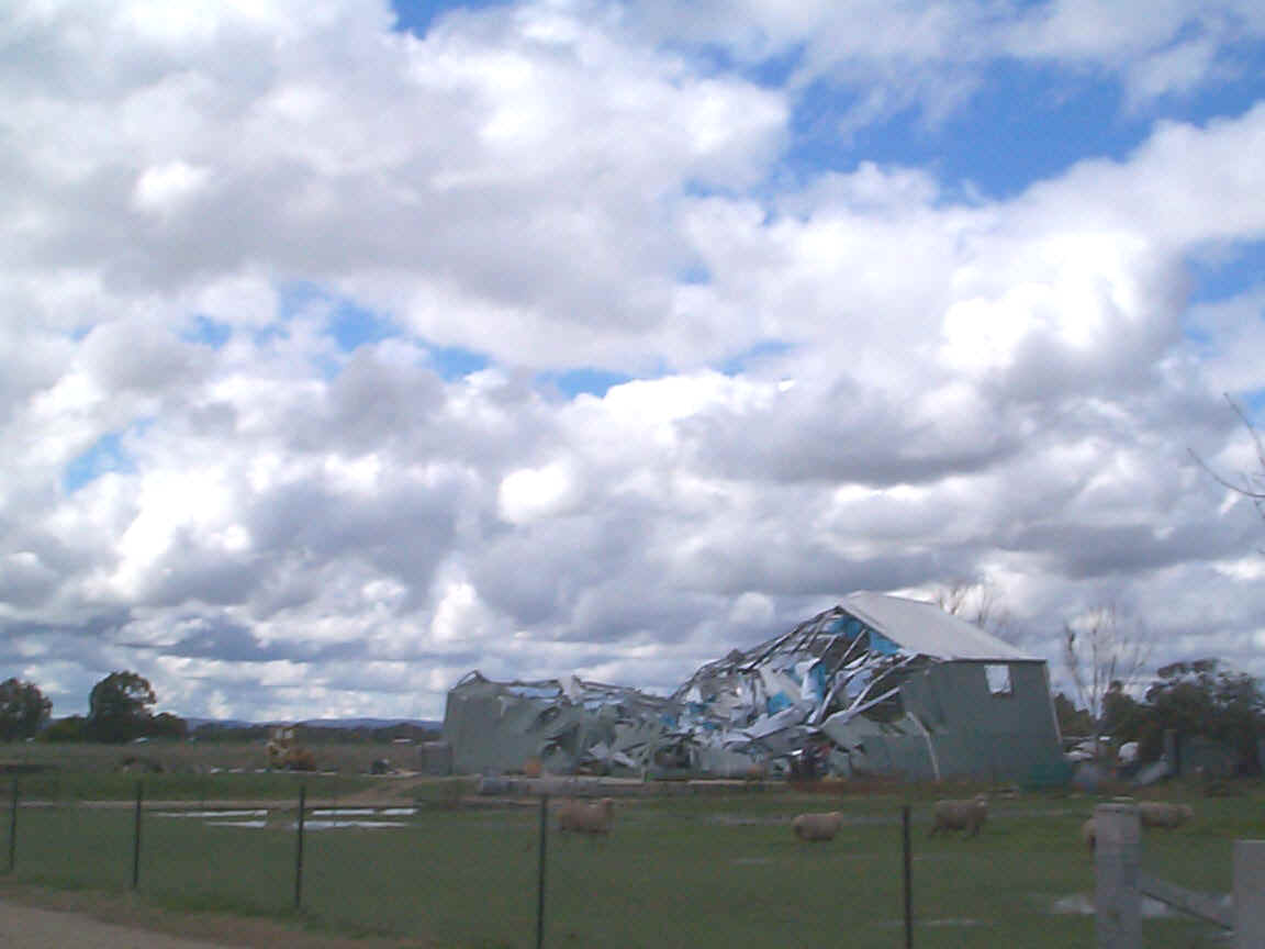
We moved on further East towards town, where they still had the road blocked off at the southern entrance to Milawa/Bobinawarrah Road from the Glenrowan/Milawa Road (Snow Road). Jane and I went into the local pub to "borrow" a power point to download the pictures from the digital camera to the portable computer, and not one person asked why we were sitting on the floor in the corner of the bar with a computer. We had to bob down though whenever they made a shot from the pool table. While doing this I noted that they had reopened the road. Back into the vehicles and drove down to the corner of Milawa/Bobinawarrah Road and Lauriston Ave, where the home is situated that bore most of the damage. The owner had been away at the time.
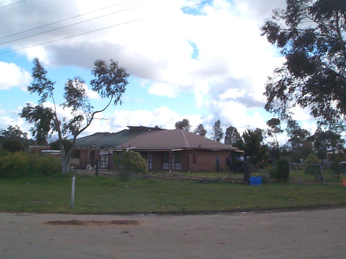
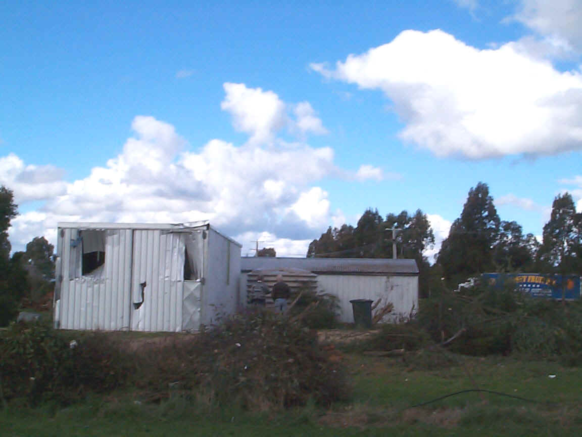
This home suffered some serious structural damage with the roof on the western side peeled off. Several other homes in this area suffered "minor" roof damage mainly from falling trees. This particular home had a filing cabinet sucked out of it and pieces were found in the shed diagonally across the road (pictured).
The wheelie bin had also "arrived" here as well. Not sure if the wind had emptied it for them though.A bus was parked in this shed at the time and all the debris etc that went through the wall landed at the front of the shed and bus, causing it no damage. Truck load after truckload of rubbish was carried away in the hour or so that I was in this area. The home on the property of this little shed had a hole in his side door about 50mm round. It was splintered on the inside, and yet nothing was found inside. The back veranda on this home was also destroyed. My family were getting restless by about 4.45pm and wanted to leave. So I had to head for home, although with an ulterior motive. Via the floods at Wangaratta’s Ovens River.... More photos of the damage can be found
at: MSL (4pm), radar loops during the hour prior to the tornado & CSIRO Image of Victoria at 0815Z Photos copyrighted to J ONeill (ASWA Archive)
A local’s account There was a thunderstorm to the SW, all of a sudden the rain became very heavy and a sudden increase in wind noise that sounded like an airplane coming. This bloke looked out to the west and saw a twister forming it was coming down from the cloud it was a light greyish colour and had tin and trees and stuff in it. It headed straight for his house, and the pressure increased with doors banging and windows rattling. He headed for the front of his home with his family, and then all of a sudden it changed direction to the NE right in his yard. There was a big round bale of hay in the yard that got tossed about 20 metres and finished up only about a foot around, with the rest strewn everywhere. He said that it was all over in a few minutes. There was about 10mm of rain but no hail, although there was very heavy rain to the south. He seemed to think that it might have skipped a few times touching some things and not others. It touched down about 7pm and was rated as an F1 tornado. People at Glenrowan to the west reported seeing two storms meet over the Milawa area. Some corrugated iron was found 5 kilometres away on a farm. The tornado path. Stated by the local
|